Using geoc to create WA State Geology GeoPackage
I love geology maps. After working on the Mars Geology map project, I wanted to see if I could do something similar closer to home. I wanted to use geoc as much as possible to create a GeoPackage database of WA State geology data with embedded styles that would work in QGIS and geoc.
I found that WA State provided surficial geology data but only in proprietary ESRI GeoDatabases.
Lets download the data from WA State.
mkdir -p data
cd data
curl https://fortress.wa.gov/dnr/geologydata/publications/data_download/ger_portal_surface_geology_500k.zip --output ger_portal_surface_geology_500k.zip
unzip ger_portal_surface_geology_500k.zip
Luckily, ogr2ogr can convert GeoDatabases (which geoc doesn’t support) to Shapefiles (which geoc supports.)
mkdir -p data/shapefiles
ogr2ogr -f "ESRI Shapefile" data/shapefiles data/ger_portal_surface_geology_500k/WGS_Surface_Geology_500k.gdb
Now we can use geoc to create a GeoPackage database. The WA State Geology data comes in EPSG:2927 or WA State Plane South.
geoc vector project -i data/shapefiles/Contacts.shp -o data/wageology.gpkg -r contacts  -t "EPSG:2927" -s "EPSG:2927"
geoc vector project -i data/shapefiles/Faults.shp -o data/wageology.gpkg -r faults  -t "EPSG:2927" -s "EPSG:2927"
geoc vector project -i data/shapefiles/Folds.shp -o data/wageology.gpkg -r folds  -t "EPSG:2927" -s "EPSG:2927"
geoc vector project -i data/shapefiles/MapUnitPolys.shp -o data/wageology.gpkg -r units -t "EPSG:2927" -s "EPSG:2927"
We have the data in our Geopackage but now we need to generate styles. The geoc command line application can generate simple styles for contacts, faults, and folds.
mkdir styles
geoc style create -s stroke="#626262" -s stroke-width=1.0 -w type=NamedLayer > styles/contacts.sld
geoc style create -s stroke="#c43c39" -s stroke-width=1.0 -w type=NamedLayer > styles/faults.sld
geoc style create -s stroke="#91522d" -s stroke-width=1.0 -w type=NamedLayer > styles/folds.sld
I needed to write a geoscript-groovy script to create styles for units. I extracted the geology map units and colors from the published PDF map and created a CSV file.
Unit,Group,Description,Color
Qd,Unconsolidated Sediments,Holocene dune sand,#f4e0b7
Qa,Unconsolidated Sediments,Quaternary alluvium,#fefbd6
Qls,Unconsolidated Sediments,Quaternary mass-wasting deposits,#f7ee95
Ql,Unconsolidated Sediments,Quaternary loess,#f9f6e6
Qf,Unconsolidated Sediments,Pleistocene outbust-flood deposits,#f0e8cd
Qgd,Unconsolidated Sediments,Pleistocene continental glacial drift,#f1ecdd
Qad,Unconsolidated Sediments,Pleistocene alpine glacial drift,#ded6c6
QTc,Sedimentary Rocks and Deposits,Quaternary-Tertiary continental sedimentary rocks and depoists,#ecf3cb
Tc,Sedimentary Rocks and Deposits,Tertiary continental sedimentary rocks,#c7d882
MZc,Sedimentary Rocks and Deposits, Mesozoic continental sedimentary rocks,#bad769
Tn,Sedimentary Rocks and Deposits,Tertiary nearshore sedimentary rocks,#ddefe6
MZn,Sedimentary Rocks and Deposits,Mesozoic nearshore sedimentary rocks,#a8d7ad
...
The groovy scripts uses GeoScript and loops over each unit to create a SLD file.
import geoscript.filter.Color

File file = new File("WashingonGeology.txt")
List<Map> units = []
file.eachLine { String line, int n ->
    if (n > 1) {
        String[] parts = line.split(",")
        String unit = parts[0]
        String group = parts[1]
        String description = parts[2]
        String color = parts[3]
        units.add([
                unit       : unit,
                group      : group,
                description: description,
                color      : color
        ])
        println "${n} ${unit} = ${color}"
    }
}

String xml = """<?xml version="1.0" encoding="UTF-8"?><sld:StyledLayerDescriptor xmlns="http://www.opengis.net/sld" xmlns:sld="http://www.opengis.net/sld" xmlns:gml="http://www.opengis.net/gml" xmlns:ogc="http://www.opengis.net/ogc" version="1.0.0">
  <sld:NamedLayer>
    <sld:Name/>
    <sld:UserStyle>
      <sld:Name>Washington Surficial Geology</sld:Name>
      <sld:FeatureTypeStyle>
        <sld:Name>Surficial Geology Units</sld:Name>
"""

units.each {Map unit ->
    Color color = new Color(unit.color)
    xml += """
        <sld:Rule>
          <sld:Name>${unit.unit}</sld:Name>
          <sld:Title>${unit.unit}</sld:Title>
          <sld:Abstract>${unit.group}: ${unit.description}</sld:Abstract>
          <ogc:Filter>
            <ogc:PropertyIsEqualTo>
              <ogc:PropertyName>Map_Unit</ogc:PropertyName>
              <ogc:Literal>${unit.unit}</ogc:Literal>
            </ogc:PropertyIsEqualTo>
          </ogc:Filter>
          <sld:PolygonSymbolizer>
            <sld:Fill>
              <sld:CssParameter name="fill">${color.hex}</sld:CssParameter>
            </sld:Fill>
          </sld:PolygonSymbolizer>
          <sld:LineSymbolizer>
            <sld:Stroke>
              <sld:CssParameter name="stroke">#aa9c80</sld:CssParameter>
              <sld:CssParameter name="stroke-width">0.1</sld:CssParameter>
            </sld:Stroke>
          </sld:LineSymbolizer>
        </sld:Rule>
        <sld:Rule>
            <MaxScaleDenominator>400000</MaxScaleDenominator>
            <ogc:Filter>
            <ogc:PropertyIsEqualTo>
              <ogc:PropertyName>Map_Unit</ogc:PropertyName>
              <ogc:Literal>${unit.unit}</ogc:Literal>
            </ogc:PropertyIsEqualTo>
          </ogc:Filter>
            <sld:TextSymbolizer>
                <sld:Label>
                  <ogc:PropertyName>Map_Unit</ogc:PropertyName>
                </sld:Label>
                <sld:Fill>
                  <sld:CssParameter name="fill">${color.darker().hex}</sld:CssParameter>
                </sld:Fill>
            </sld:TextSymbolizer>
        </sld:Rule>
        """
}

xml += """
      </sld:FeatureTypeStyle>
   </sld:UserStyle>
  </sld:NamedLayer>
</sld:StyledLayerDescriptor>
"""

File dir = new File("styles")
dir.mkdir()
new File(dir, "units.sld").text = xml
Let’s run that script.
geoscript-groovy styles.groovy
OK, the SLD styles are created, now we can use geoc to add them to our GeoPackage.
geoc style repository save -t sqlite -o file=data/wageology.gpkg -l units -s units -f styles/units.sld
geoc style repository save -t sqlite -o file=data/wageology.gpkg -l contacts -s contacts -f styles/contacts.sld
geoc style repository save -t sqlite -o file=data/wageology.gpkg -l faults -s faults -f styles/faults.sld
geoc style repository save -t sqlite -o file=data/wageology.gpkg -l folds -s folds -f styles/folds.sld
This still won’t work with QGIS, because QGIS expects the styles to be in the QML.
I found a tool called GeoStyler that can convert a SLD to QML.
First, we need to create a package.json file in our project directory.
{
  "name": "wageology",
  "version": "1.0.0",
  "description": "WA Geology Scripts",
  "author": "Jared Erickson",
  "license": "MIT",
  "devDependencies": {
    "geostyler-cli": "0.0.2"
  }
}
Then we can install the node library.
npm i
Finally, we can convert our SLD files to QML and load them into our GeoPackage using the sqlite command line tool.
cd styles
for f in *.sld
do
    NAME="${f%%.*}"
    echo "Converting $f to $NAME.qml..."
    npx geostyler-cli --output $NAME.qml $f

    SLD=`cat $f`
    QML=`cat $NAME.qml`
    OWNER=`whoami`

    SQL="UPDATE layer_styles
            SET styleQML = '${QML//\'/\"}'
            WHERE f_table_name = '$name'
            AND stylename = '$name'
    "

    sqlite3 ../data/wageology.gpkg "$SQL"

done
cd..
Our GeoPackage now has data and styles.
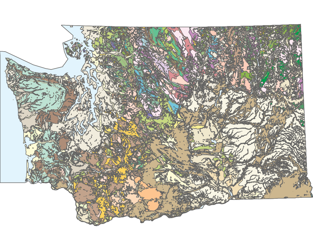
We can use geoc to visualize our geology map.
geoc map draw -f wa_geology.png -b "575347.999869466, 81877.0000796467, 2551197.99993323, 1355563.99994464" \
    -l "layertype=layer file=data/wageology.gpkg layername=units style=styles/units.sld" \
    -l "layertype=layer file=data/wageology.gpkg layername=contacts style=styles/contacts.sld" \
    -w 1000 -h 800

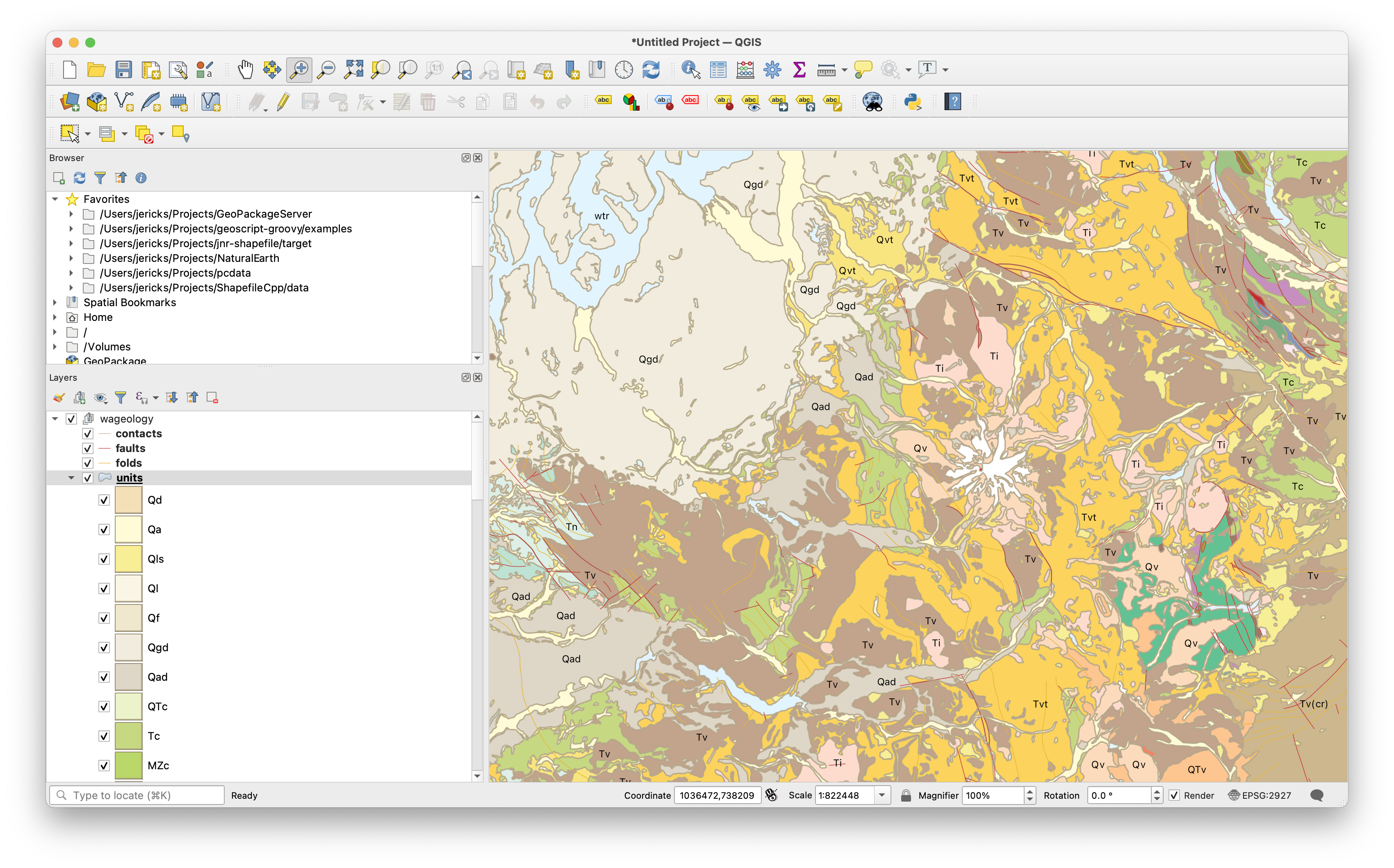
We can also view our map in QGIS.
